Travel Planner
“Our First Keweenaw Adventure”
Episode #2208 Travel planner
We take a look back when life was nothing but fun and every trip was new. This time we go back to the Keweenaw before it was the crowded place that it has become today. I think you will enjoy these tales from the past.
Comment
Tell us what you thought of this episode and get information & guides to the areas featured by filling out the comment form
Comment Form
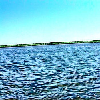
Keweenaw Peninsula, Michigan
Visit
visit the official website of Keweenaw Peninsula area tourism and plan your visit
Visit KeweenawThe Keweenaw Peninsula
Location: NW section of Michigan's Upper Peninsula. Travelers can reach the Keweenaw by land via US 41 or M-26. It is about 2 hours away from Marquette, MI and about 4 hours away from Green Bay, WI.
In the native Ojibwe language “Keweenaw” roughly translates to “the crossing place” and today, its natural beauty and history draw people seeking to experience outdoor adventure in a rugged, remote wilderness setting. The Keweenaw Peninsula is in the heart of Lake Superior in the northern most part of Michigan’s Upper Peninsula.
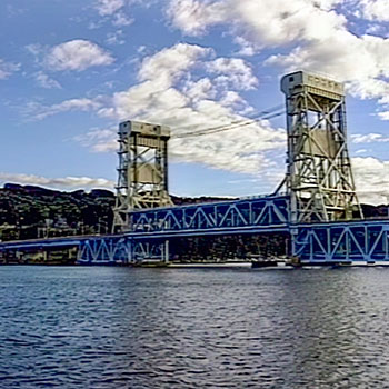
The Keweenaw region has several small towns which formed around the area’s copper mining industry during the 1900s. The cities of Houghton and Hancock, connected by the Portage Lake Lift Bridge spanning the Keweenaw Waterway, are the largest communities. Smaller towns, like Calumet, Chassell, Copper Harbor, Eagle Harbor, and Eagle River, have their own personalities and ways to experience UP north.
The Keweenaw is home to hundreds of miles of outdoor recreation trails, countless beaches and waterfalls, and thousands of acres of pristine wildness perfect for summer and winter outdoor activities. While many visitors enjoy explore the Keweenaw’s backcountry, the area's collection of national, state and local parks offers access to an abundant collection of natural and historical attractions.
The Keweenaw is also well known for its collection of historical attractions which preserve the region’s copper mining heritage. The Keweenaw National Historical Park, along with a collection of 20+ heritage sites allow visitors to explore the region’s history and the industry’s impact on the land and people. Popular experiences include tours of the Quincy Mine and Delaware Mine, the A.E. Seaman Mineral Museum, lighthouse tours and local museums.
Houghton
Location: Houghton, Michigan
Houghton is often referred to as the Gateway to the Keweenaw blending the great outdoors with rich history and small town charm. Resting on the southern shore of the Keweenaw Waterway, Houghton is home to Michigan Tech University, a vibrant historic downtown, numerous family-friendly parks, recreation trails, and locally-owned dining options. Houghton's mix of shopping, lodging, and entertainment make it a great option for visitors seeking a basecamp for trips to Isle Royale National Park, Copper Harbor and Porcupine Mountains Wilderness State Park.
Douglass Houghton was an American geologist and physician. His efforts on behalf of the State of Michigan contributed greatly to the discovery and subsequent commercial exploitation of copper in Michigan's Upper Peninsula, as well as an enhanced knowledge of the state’s flora, fauna, and geology. While he is primarily remembered for his role as the state's first leading geologist, Houghton was also active in politics and was highly regarded for his erudition and academic knowledge.
- Houghton [Visit Keweenaw]
- Douglass Houghton [Detroit Historical Society]
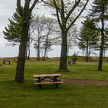
F.J. McLain State Park
Location: 18350 Highway M-203, Hancock, Michigan
Size: 443 Acres
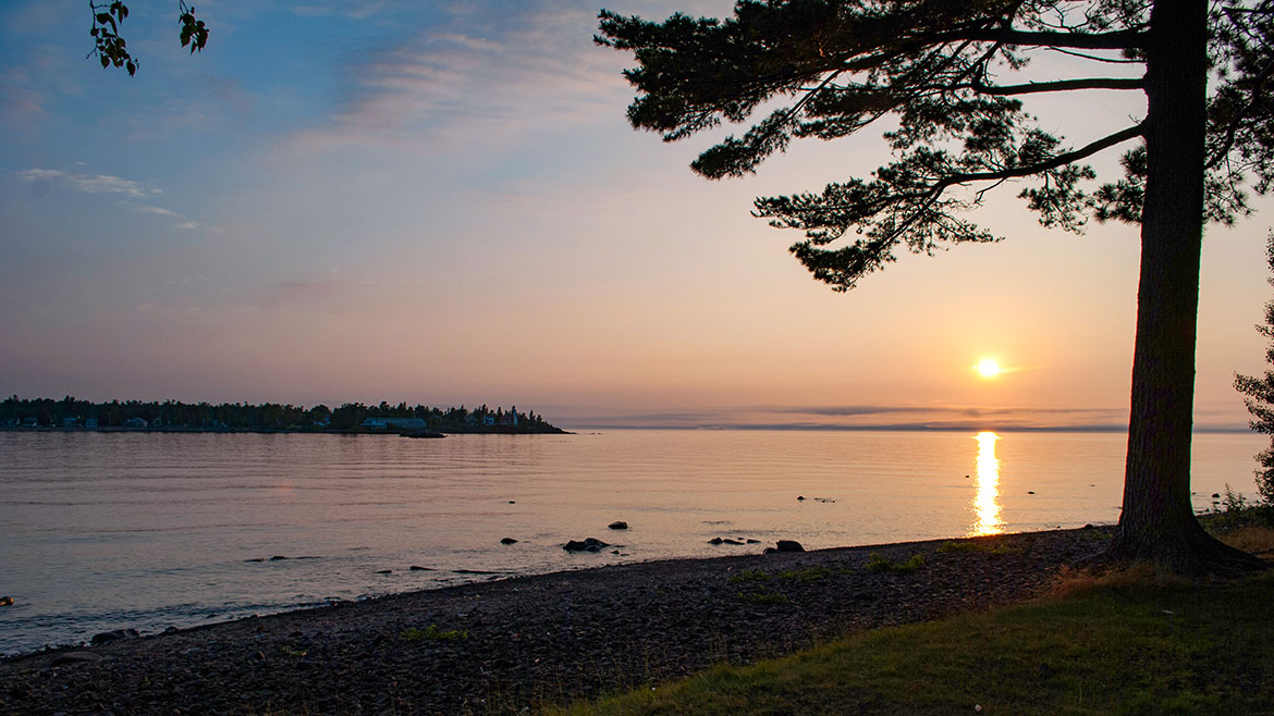
McLain State Park is situated in the heart of the Keweenaw Peninsula on beautiful Lake Superior and is centrally located between the cities of Calumet and Hancock. The park offers two miles of sand beach on Lake Superior. Visitors can also enjoy a variety of activities in the park: fishing, windsurfing, berry picking, beachcombing, rock hounding, sight-seeing and hunting. The sunsets at McLain State Park are spectacular and the view of the lighthouse is magnificent. The park serves as a great homebase for those wanting to explore the western U.P. Visitors will find attractions such as abandoned shafthouses, tram cars, "poor rock" piles, ghost towns and the Keweenaw National Historic Park.
- McLain State Park [Michigan DNR]
- McLain State Park [Visit Keweenaw]
Laurium Manor Mansion
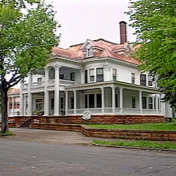
Location: 320 Tamarack Street - Laurium, Michigan
Phone: (906) 337-2549
Thomas Hoatson Jr., owner of the Calumet & Arizona Mining Company, built this 45-room, 13,000 square foot home in 1908 using the finest and rarest building materials available. Mansion tours are self-guided and takes 30-60 minutes. Printed guide and smartphone audio tours are included. Lodging at the mansion is available year-round.
The Keweenaw Heritage Sites are official partners of Keweenaw National Historical Park, but are privately owned. Each site interprets and preserves an important aspect of the area's copper mining history and provides a unique visitor experience.
- Laurium Manor Mansion [National Park Service]
- Laurium Manor Inn [Visit Keweenaw]
- Laurium Manor Inn
Houghton Douglass Falls

Location: Hammell Creek just off Highway M-26 between Laurium & Lake Linden, Houghton County, Michigan
Douglass Houghton Falls is Michigan's tallest waterfall at 110 feet from the top where Hammell Creek cascades to its base. It is located in Michigan's Upper Peninsula between Laurium and Lake Linden just off Highway M-26. Prior to 2018, the waterfall was privately owned and access to the waterfall was restricted due to its dangerous geological makeup. The waterfall is situated in a deep gorge that is flanked by sharp loose rock. The land was acquired by the state of Michigan in 2018, with plans to turn Douglass Houghton Falls into a state scenic site and veterans memorial.
- Waterfalls [Visit Keweenaw]
- Veterans Memorial Scenic Site [Michigan DNR]
Eagle River Falls
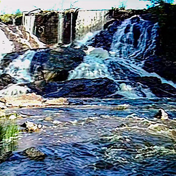
Location: Eagle River
5055 M-26 - Eagle River, Michigan
The Upper Eagle River Falls, or 10 Foot, is located north along M-26 approximately .8 miles from the US-41/M-26 junction in Phoenix. Watch for a small roadside parking area on your right.
Located along the south side of M-26 as it enters the village of Eagle River. A parking area and pedestrian bridge just off M-26 make viewing these falls very easy. The falls is on the site of the original Lake Superior Fuse Company and remains of the dam still span most of the 60-foot wide river. The dam extends the falls to a total height of well over 60 feet. Water drops over the dam in a straight sheet, forms tendrils that flow over the rocks forming its steep banks then rejoins at the bottom of the deep gorge.
- Lower Eagle River Falls [Visit Keweenaw]
- Upper Eagle River Falls [Visit Keweenaw]
Lake Bailey

Location: Highway M-26 - Eagle Harbor, Michigan
Lake Bailey, in Keweenaw County, is a 204 acre lake with an average depth of 3 to 6 feet known for big, fat perch and northern pike. Public access site and shallow boat launch at the north end of the lake along M-26 east of Eagle Harbor.
- Lake Bailey [Visit Keweenaw]
Gratiot Lake
Location: Gratiot Lake Road - Mohawk, Michigan
The largest of Keweenaw Counties inland lakes, Gratiot is 1,438 acres with a maximum depth of 70 feet. Large northern pike, perch, tiger muskie and walleye lure anglers. Public access site and boat launch. South of US-41 at Central on the Gratiot Lake Road.
The 100-acre Gratiot Lake Overlook Nature Sanctuary offers a spectacular view of Gratiot Lake. The trail is moderately difficult with a 400 foot gradual rise in elevation. About 1.5 miles round trip. To get there follow US-41 North of Calumet to the sign for Gratiot Lake. Turn right and travel 5 miles to the bottom of the hill. Turn left and drive .75 miles to the DNR public access site on Gratiot Lake and park. Cross the road to reach the trailhead.
- Gratiot Lake [Visit Keweenaw]
- Gratiot Lake Overlook Nature Sanctuary [Visit Keweenaw]
Central
Location: north of Calumet, Michigan
CENTRAL MINE MUSEUM COMPLEX
Location:670 Lighthouse Road - Eagle Harbor, Michigan
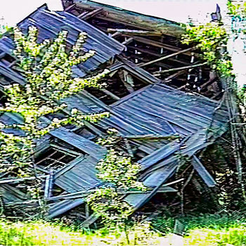
The town of Central is about 20 minutes north of Calumet, Michigan. The town was established in 1854 after a mine was opened on a discovered fissure deposit of copper. Central Mine was the first copper mine in the region to bring in a profit during its first year of operation. At its peak, the bustling town’s population soared to 1,350. Unfortunately, after 40 years in operation the mine’s copper ran out and the mine closed in 1894. The population plummeted, and the boomtown went bust.
The community, now a part of the Keweenaw County Historic Society Museum Complex, was settled around the Central Mining Company in 1854. Many of the residence exteriors have been restored and a visitors center provides interpretive exhibits about Central. There are two walking paths, a memorial garden, and three building open to visitors.
- Keweenaw Ghost Towns [Visit Keweenaw]
- Central Mine Museum Complex [Visit Keweenaw]
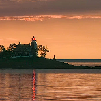
Mendota (Bete Grise) Lighthouse
Location: Mendota Point - Lac La Belle, Michigan
The original tower was built in 1870 on Mendota Point to guide ships into Lac La Belle through the Mendota Ship Canal. The present lighthouse was built in 1895 and abandoned by the Coast Guard in 1960. It is now a private residence.
- Mendota Lighthouse [Visit Keweenaw]
- Mendota Lighthouse
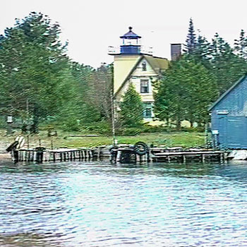
Eagle Harbor Lighthouse
Location: 670 Lighthouse Road - Eagle Harbor, Michigan
Located at the west end of Eagle Harbor, the present brick structure was built in 1871. It is now a part of the Keweenaw County Historical Society's Light Station Museum Complex and is open to the public. Since 1982 the Keweenaw County Historical Society has maintained four museums at the light station: a Maritime Museum in the old fog signal building, a Keweenaw History Museum located in the old U. S. Coast Guard Station garage, and Commercial Fishing Museum located in one of the assistant keepers' buildings. Guided tours of the Eagle Harbor Lighthouse and accompanying museums take place mid-June to mid-October. During the winter season, the exterior grounds are open for self-guided viewing.
- Eagle Harbor Lighthouse [Visit Keweenaw]
Copper Harbor

Location: Copper Harbor, Michigan
In the early 1870’s when the copper rush started, Copper Harbor quickly became a well-known entry to the peninsula. Home to Fort Wilkins, which was built for the Army to occupy and keep order, the village was an outlet for copper leaving the Keweenaw. Today, you’ll find this small town brimming with energy and Pacific Northwest vibes thanks to mountain bikers and outdoor enthusiasts seeking respite in one of the Midwest’s last undiscovered special places.
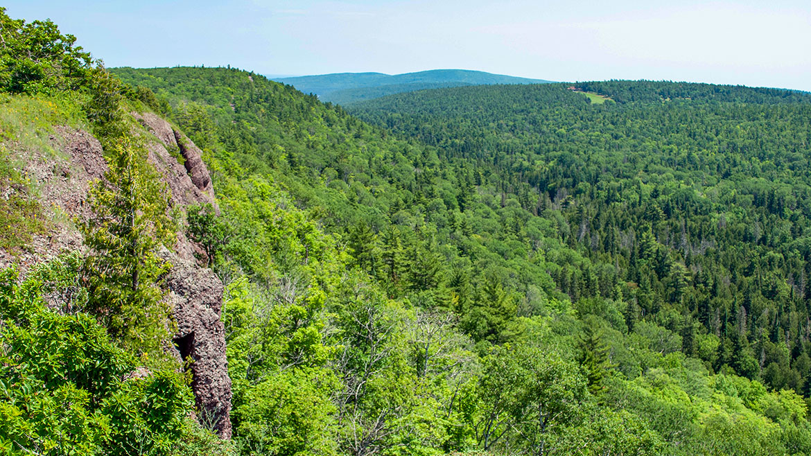
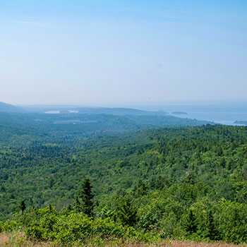
Offering unparalleled views of the Keweenaw wilderness and Lake Superior, Brockway Mountain is one of Copper Harbor’s most beloved attractions. Visitors can opt to enjoy a scenic 9.5 mile stretch off M-26 between Eagle Harbor and Copper Harbor to enjoy the views (up to 1,300 feet above sea level), or climb the peak by bike and enjoy incredible downhill singletrack trails. In the spring, Brockway Mountain serves as a key stop along the annual North American hawk migration pathway. Visitors can enjoy viewing dozens of raptors soaring on upward thermals which help rest tired wings as the birds seek prey to power their journey. Constructed in 1933 through a federal work program, the road is named in honor of Daniel Brockway, one of the original residents in this region of the Keweenaw Peninsula.
- Copper Harbor [Visit Keweenaw]
Brockway Mountain Drive
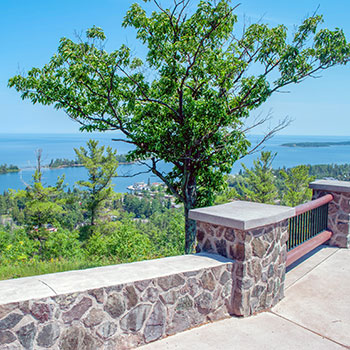
Location: Brockway Mountain - Copper Harbor, Michigan
Brockway Mountain Drive, a scenic route in Michigan’s Keweenaw Peninsula, stretches off M-26 between Eagle Harbor Township and Copper Harbor. Brockway Mountain Drive is the highest drive above sea-level between the Rockies and the Alleghenies. The nine-mile stretch snakes up Brockway Mountain and was constructed in the early 1930s as a Great Depression project to employ more workers and to create a valuable destination asset. The two-way, nine-mile scenic drive on Brockway Mountain features several breathtaking viewing platforms and connects to numerous trails for mountain bikers and hikers. This picturesque mountain peak serves as a wildlife sanctuary, offering a serene retreat and an adventurous destination. Enjoy 360-degree views of Lake Superior, spotting passing freighters on the horizon.
- Brockway Mountain Drive [Visit Keweenaw]
- Brockway Mountain Overlook [Visit Keweenaw]